This was a special day to be at this statue. If you remember we have a picture of us at Mile 0 in Victoria where there is a statue commemorating where Terry would have completed the trip. We are not sure what there will be in Saint John's but we think we will find it especially meaningfull as we will have completed our odyssey at that point.
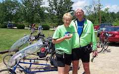
 These are 2 tour vets that have joined us for a leg of this 2009 trip. John, on the left, has been assigned to my galley crew. James is in training for a 2010 Ironman.
 We had to leave our mark on the Courage Highway. We feel very courageous tackling this challenge.
 Part of the highway from the statue to just west of Nipigon is called Courage Highway.
  Quite the talent in these murals on the Esso station at Dorion. We now have a better idea of what to look for when we are scouting for moose.
 This mural is exceptionally detailed.
 The gang staying out of the storm.
 We travelled through Red Rock. The pavement is actually red in colour in sections.
 We noticed the cliff areas looking a lot like the Niagara escarpment.
 I think we pass construction very day. The other day was 10 km of wet gravel. From what we were told a few cyclists got flats on that gravel road.
 We are assigned a shelf in the truck and have two black bins to store our things. The ones with the white covers are my bins. I also have a tent bag that gets stored on the floor of the truck during the day. This who get to camp first get to unload. I have never done that as Terri and I end up usually close to the last ones in. We have however assisted in loading the truck when it is our trun to cook breakfast. Some of those tent bags weigh a ton.
 This is the beautiful bubbling water we are camped beside tonight.
This is a rare treat to do a posting two days in a row. I thought I might as well take advantage of this connection in Nipigon as we have five days of continuous cycling ahead of us. We are camped at a small private site just west of Nipigon which we ride through tomorrow. We are situated by the side of a bubbling creek and just off the highway enough that the traffic will not bother us.
We left the University this morning and because we had a hill to climb we got to see some of the city that we missed on our rest day. We basically spent our rest day time drying things out and getting organized for the next leg of the trip. Bike cleaning also takes a fair chunk of time out of the day and we had some major grit and grime to clean. Our room was quite a piece from the truck so we had to make use of the trolley to get our stuff from point A to B. We did manage to get a cab to do some shopping at Walmart and we had a nice supper at Kelsey's. Our cab driver assured us we would have good weather for the next little while. We knew better but thanked her anyway. Who knows, she might have an in with somebody.
We had a special treat today. We had our first stop at the Terry Fox memorial. His statue sits high on a hill overlooking Thunder Bay area. You can't see him from the highway but you sure can see lots when you are up there. The weather cooperated for the photo shoots, one of which will be sent to our Terry Fox organizer, Susan as she will be getting busy for the run. Terri has done rides for the last several years and I joined her for the last three. We did an overnight trip to Tobermory last year, 342km. Together we raised over $4,000 for the fund. We will not be back in time to do it this year so we hope all our regular sponsors will pledge others or participate themselves. We will be back next year which is an anniversary year, 30, I think.
The highway from the statue to just before Nipigon is named Courage Highway after Terry's challenging trip across Canada. We had to leave our mark as well. We just hope the rain did not wash it away.
Our route today took us along Lake Superior and the road took us off the highway along cottage roads. Very nice vacationing here.
The weather really turned for the worse after our late morning coffee break. Fortunately we saw it coming and had our rain gear on but it came down so hard that we had to pull off the road, we could not see anything and at 35 km/hr the rain really hurts. We came into an Esso station when we could get going again and waited it out. Thunder and lightning went on for over an hour but we had good company as many other cyclists had taken shelter there as well. This made for a longer day and we had hoped with just 113km we would get in early. We did arrive safely though and that was what was important today. This is a busy highway and there were spots where the pavement was rough and sometimes the shoulder very narrow. Constantly checking your mirror was necessary and if someone looked like they would not give you room, well, we move over. The alternative is not pretty in that situation.
The Esso station was adorned with beautiful murals as you saw in the picture. More than one person told us today that we would have some major hills today to get us to Nipigon but we found them not too challenging. I think we are in for some bigger ones as we make our way around Lake Superior.
Till the next time I can get connected, take care, stay healthy and thank you all for your great comments and support sent to us through your emails. Everyday has its challenges.
Holly